About the company
About GRM
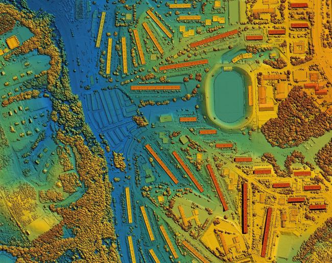
Since 2003, we’ve been dedicated to delivering high-precision maps that empower better planning, smarter design, and informed decision-making. What began as a specialized photogrammetry company has grown into a multidisciplinary geospatial and planning powerhouse with over two decades of proven expertise.
Today, our capabilities span far beyond traditional mapping. We operate across the full spectrum of geospatial services—Photogrammetry, LiDARgrammetry, Drone Survey, Ground Survey, Aerial Triangulation, Orthophoto Production, and High-Impact Visualizations—and have expanded into Master Planning and MEP services to support end-to-end project development. Our team includes operators trained in the USA under ASPRS, County, and DOT standards, along with highly skilled compilers who have mastered their craft through intensive one-on-one training. This blend of global exposure and hands-on expertise ensures that every dataset we produce meets the highest benchmarks of accuracy, precision, and visual clarity.
Quality is at the heart of everything we do. With dedicated QA and QC teams, rigorous workflows, and a commitment to on-time delivery, we consistently provide engineering-ready outputs that clients can trust. From mapping to modeling, from surveys to planning, we continue to evolve—bringing innovation, reliability, and 3D intelligence to every project we undertake.

We are Skilled
20+ years of transforming imagery into ASPRS-grade precision maps with accuracy and aesthetic excellence.
We are Trained
We have operators trained in the USA under ASPRS, County, and DOT standards, supported by highly experienced compilers who have received one-on-one, hands-on training to master the craft of precision map production
We are Professional
We deliver maps of the highest accuracy and quality, supported by dedicated QA/QC teams that validate every detail without compromising timelines.
Mapping our growth, step by step
Our Journey
We’ve been delivering exceptional maps over the past 20+ years. Our capabilities have grown far beyond traditional mapping—evolving into a full-spectrum geospatial and planning powerhouse. From flying drones and conducting ground surveys to triangulating projects, generating orthophotos, producing high-impact visualizations, and now offering master planning and MEP services, we continue to expand our expertise to meet the evolving needs of our clients. What began as a mapping company has grown into a multidisciplinary team delivering end-to-end geospatial intelligence, design support, and planning solutions with precision, innovation, and reliability.